Stroud Trail Quarter Marathon

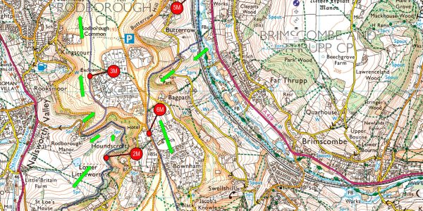
Then, it’s a sharp left turn, then up and over the canal, back under the viaduct and on the eastwards heading canal towpath.
After a mile, it’s time to turn off the towpath and head back up to Rodborough common. This climb is considerable, but well worth it, arriving at the top at Winstones Ice Cream Shop and factory. maybe a visit after your accomplishment.
Continuing up past the Bear Inn and onto Minchinhampton common. Now all that’s left is head back over the common to the finish.
-
Event information
-
When: 12th May 2024
-
Start Time: 11:30am
Race bibs & Shoe Tags can be collected from 7am at Race HQ
Race briefing will be at 11:20am on the start line. -
Where: Great Park, Minchinhampton
Race HQ is Minchinhampton Academy
Start & Finish is the Great Park on the common at the back of school -
Entry Fee: £22
There is an additional £2 for unaffiliated runners
-
Min age: 16yrs
-
Registration closes: 8th May 2024
or earlier if entry limit is reached
-
No entries on the day
-
Read race information
Information, running advice, raceday address, contact details, directions and parking instructions
-
Final Instructions Email
An email will be sent out the week beginning 29th April
-
Parking
There is no specific car park for this event. There are 30 spaces at the school, but the rest of parking is street parking. Please check the map.
-
Directions
-
Prizes & Awards
-
Bespoke medal to all finishers
-
technical T-shirt
Your T-shirt & size is guaranteed before 21st April. After this date you may not get a T-shirt or it may not be your size.
-
Awards 1st, 2nd & 3rd Lady & Man
-
Run details
-
Distance: 7.6M (12.2Km)
-
Trails: 99% Road 1%
-
Total Ascent: 1050ft (320m)
-
Lowest: 142ft (43m) @ 4.2M
-
Highest: 678ft (206m) @ 1.3M
-
Checkpoints & Maps
There is only 1 checkpoint on the Quarter Marathon
Water, First Aid & Timing Split
OS Maps Ordnance Survey Online
If you subscribe to the OS Maps online, then you can view the route here. You also download the GPX file and view a 3D fly through


